 How many of us are guilty of conducting a GPS-based approach for it’s convenience, without really understanding the underlying principles or knowing all the pertaining regulations? I, for one…
GPS use has become so widespread and easy to acquire (even through dash-mounted modules) that you will meet very few pilots who have not used it at least once. As for me, I have had the chance to experience both sides of the IFR world with a GPS. During the first two years of my career, I had the pleasure to fly 40 years old Chieftains, equiped with the basic IFR instruments and, oh wonders!, a dash mounted Garmin gps.
Needless to say, despite the simplicity of the module, it was an extremely convenient tool which allowed us to cut a few corners during en-route navigation. However, when came the time to conduct an approach, we had to rely on the good old, twice-my-age “steam gauges”. I even remember the look of horror my copilot and I exchanged the first time we were asked to conduct a DME-ARC transition to intercept an ILS, as neither of us had done one since flight school. Ugly. Then came the PC12NG.
Equipped with dual IFR GPS coupled to the autopilot, the NG really transformed the world of instrument flying for me. Going from full-procedure approaches to self-vectored straight-in approaches every where was a real treat. However, despite the full automation of the airplane, the fact remains that pilots are always ultimatly responsible for the safety of the flight and the adherence to the air laws. And it so happens that GPS regulations can be somewhat… tricky! Since the use of GPS for terminal and approach modes has been allowed for many years now, there is a wide variety and flavors of modules (old and new) on the market, with as many rules pertaining to their use.

But lets cut to the chase. You have an awesome GPS in your airplane. You want to use it for an approach every time, because, well, it’s just so much fun! Question: Do you have RAIM? FDE? WAAS? Are you using it at destination or your alternate? Tricky Tricky? Not so much. I believe that with the more and more popular use of GPS for enroute and arrival procedures, it is crucial that pilots be knowledgeable about this powerful tool.
- Introduction to GNSS
- Nav Performance Requirements and Basic Principles
- Approach Criteria
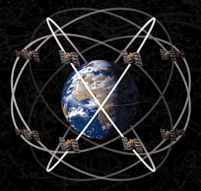
Global Navigation Satellite System (GNSS)
 Despite the popular belief, GPS is actually more of a brand than a name. It’s like calling all SUVs Jeeps. True, the first to setup and use a GNSS network were the Americans, with the GPS (Global Positioning System) constellation. However, there are two navitaion satellite systems in orbit today: The U.S. GPS and the Russian GLONASS (Global Navigation Satellite System). The European Union is also planning on launching the first four satellites of its new Galileo Constellation later this year.
At the moment, only GNSS based on the American GPS constellation is approved for aviation use. It offers the flying industry many advantages, resulting in shorter flight times between airports (direct routes) and cost saving in fuel, as well as more sophisticated instrument approaches everywhere – thus increasing safety in the more remote airports.
Nav Performance Requirements and Basic Principles
GPS installations in airplanes have to meet the following international safety standards:
- Accuracy – Measure of position error
- Integrity – Measure of trust that can be placed in correctness of the information
- Continuity – System’s capability (expressed as a probability) to perform its function throughout a specific operation
- Availability – Portion of time during which the system is able to deliver the previous 3 requirements for a specific phase of flight.
Basic Principles
A lot can be said about the clockwork of the GPS constellation. But today is all about making things easy. So for the sake of simplicity, here are the basics: the GPS constellation is comprised of 30+ (24 active) satellites. Each satellite transmits a unique coded signal, allowing identification by receivers.
GPS positioning is based on a precise calculation of timing, providing a distance – called pseudorange. A receiver normally needs four pseudoranges to calculate a three-dimensional position. In addition to position, GPS receivers can also calculate velocity – both speed and direction of motion. For applications requiring high accuracy, GPS needs space or ground-based augmentation systems (we’ll talk about those later).
As of now, an airplane still needs to be equipped with traditional ground aids as backup.
Augmentation Systems
In order to meet the four basic safety standards of use (accuray, integrity, continuity, availability), three augmentation systems have been designed for aviation.
1. Aircraft-Based Augmentation System (ABAS)
The usual components to an ABAS system onboard an airplane will include INS, LORAN, etc. However, although they are not technically considered ABAS, RAIM and FDE are often included in that category.
RAIM – Receiver Autonomous Integrity Monitoring – “is a technology developed to assess the integrity of GPS signals in a GPS receiver system.” (Wikipedia). RAIM uses extra available satellites to compare timing solutions and detect problems. It takes 4 satellites to compute a navigation solution. RAIM uses a minimum of 5 for its function – the extra satellites acting as comparative benchmarks.
 There are three levels of integrity required from the GPS system depending on the phase of flight.
– En Route: 2NM
– Terminal: 1NM
– Approach: 0.3NM
If the number of satellites in view (or their geometry) does not fulfil the required alert limit (integrity), the RAIM function will not be able to guarantee the integrity of the position solution and will alert the pilot, while continuing to provide navigation. In simple words, the RAIM function is similar to a dual VOR check airborn.
A more advanced type of RAIM can detect satellite errors or malfunction which may cause accuracy degradation that exceed the alert limit for the current phase of flight. In this case, the avionics will not only alert the pilot but deny navigation guidance by disabling the module with red flags.
FDE – Fault Detection Equipment – on the other hand, improves the continuity of operation in the event of a satellite failure (i.e.: in the case of primary-means oceanic operations)
FDE minimizes the possibility of losing RAIM by removing malfunction satellites that you could confuse or overload the RAIM function (i.e., it is an add-on). FDE is automatic and similar to the function in older IFR-certified GPS that permits to manually remove satellites listed as malfunctioning through military NOTAMs. To achieve this, it needs a minimum of 6 satellites with good geometry – allowing to continue navigation in the presence of a satellite malfunction.
BARO-AIDING. Most IFR certified GPS modules also accept signals from an aircraft altitude encoder. Refered to as baro-aiding and it basically reducses the number of satellites required by one, increasing the availability of RAIM and providing an additional measure of tolerance to satellite failures (FDE). With BARO-AIDING, the number of satellites required for RAIM falls back to 4.
Summary – ABAS
Navigation solution requirements: 4 Satellites
RAIM: 5 satellites. Detects integrity degredation.
FDE: 6 satellites. Detects satellites malfunctions.
2. Satellite-Based Augmentation System (SBAS)
Instead of relying on airplane-based integrity and accuracy monitoring, SBAS offers a much more powerful and precise alternative.
SBAS uses a network of ground-based reference stations that monitor the GPS constellation’s signals and relay data to master stations, which in turn assess the signal validity and compute necessary corrections. The master stations then relay two primary messages: integrity and range correction.
These two primary messages are transmitted to the users via geostationary satellites in fixed orbit over the equator – hence SBAS.

Source: Taipei FIR CNS/ATM
The integrity message provides direct validation of each GPS satellite’s signal, thus removing the necessity for the RAIM’s extra (fifth) satellite.
The range correction compensate for the errors introduced into the range measurements as a result of the ionosphere. By compensating for these errors, SBAS receivers become accurate enough to support advanced flight operations with vertical and lateral guidance (approaches) as accuratly as an ILS. Unlike BARO VNAV – GPS with encoded altitude signals from altimeter – SBAS vertical guidance is not subject to altimeter setting errors, and does not require temperature correction or a local altimeter setting.
SBAS is also refered to as WAAS (Wide Area Augmentation System). The first SBAS was actually the U.S. FAA’s WAAS. The use of WAAS has been permitted in Canada since 2003, and vertical guidance provided by WAAS receivers is now authorized for RNAV approaches (pending certain training and pilot proficiency conditions).
3. Ground-Based Augmentation System (GBAS)
Also called Local-Area Augmentation System (LAAS), this system sends signal corrections directly to the receivers from a ground station at an airport.
The goal of GBAS is to eventually support all precision approach categories as well as surface movement guidance. However, comparatively to ABAS and SBAS, it provides service over a limited area – usually within 30 NM of the ground station.
One of the main advantages cited for GBAS is the use of flexible approach paths, reducing both air time and polution/fuel consumption at the same time.

Source: Singh Corporation
Use of GPS and WAAS for IFR approaches
Come back soon for part 2 of this article. A lot more remains to be covered, as rules have been changing rapidly in the last few years regarding the use of GNSS and WAAS at destination and alternate planning.
More information can be found online, especially via official publications such as the FAA and Transport Canada AIMs.
You can find PART 2 of this article Here.
Thank you for reading, and I am looking forward to your comments!
*****************
Note: A special aknowledgement to Mireille Goyer from Women of Aviation, for her professional input in this article.


[…] we go any further, I would strongly suggest that you read the first part of this article (if you have not done so already) to familiarize yourself with a few terms and basic underlying […]
[…] we go any further, I would strongly suggest that you read the first part of this article (if you have not done so already) to familiarize yourself with a few terms and basic underlying […]
Great article and great blog. As a low hours student pilot I know I will be checking in regularly.
Thank you Nick! I am truly honoured with your kind words and interest! I hope to be able to provide the aviation community with more tutorials as this one in the future 🙂
Safe flying and good landings!